
‘Cherryvalley’ tells the story of how a once rural and village environment which existed in bygone times became a part of Greater Belfast suburbia. It explores the development of several thoroughfares which cross the area including the Old Dundonald Road, King’s Road, Sandown Road and of course Cherryvalley Village. In addition there are stories of people and places such as Clugston’s shop, the Belfast and County Down Railway and the Cherryvalley ARP.
Development of Cherryvalley
On 22nd May 1957 the Belfast News-Letter carried a fairly critical article on the planning of town and country in Ulster: The rapid and horrific spread of Belfast after1850 was such that the citizens lost heart in the city as a dwelling place and decided that to live at all they must live in the suburbs. The wealthy merchants built lovely places on the Malone and Bangor Roads and planted woodlands which until recently we still enjoyed. The middle classes moved out to Knock, Cliftonville and Antrim Road.
The city having lost what urbanity it had and being given over wholly to commerce and industry, the new and important buildings which should normally have been in the centre were sited in the suburbs and so we have Queen’s University, the Museum and Art Gallery and Stormont far from the heart of the city.
If you want to live pleasantly you think you must live outside Belfast and travel daily by increasingly expensive transport. Take for instance the Bangor Road (Holywood Road). It is so wide at Ashfield that an elderly person crosses it at their peril. The road continues encased in trolleybus wires to the city boundary.
John Griffiths in his commentary of the Knockdene (or Knockdeane) area for Old Ordnance Survey Maps, Belfast 1902 describes how the area had developed: Knockdene Park was not the only area of late Victorian high class housing to be developed on this map. Some of the houses shown on Cherry Valley Road south of the Knock River survive with attractive views over the wooded river valley. Eastwards………the lavish houses of Marietta and Thorn Hill …to the north of the Newtownards Road basking in the reflected glory of Ormiston the houses along Hawthorden Road, like Knockdene were built on nursery lands. However the map shows little or no workers’ housing, if one excludes the small farms and farm cottages dotted around the south. There are a few exceptions: a short terrace at the eastern end of Barnett’s Road (Stormount Terrace) and around the junction of King’s and Gilnahirk Roads near the extended city boundary of 1895 at the eastern end of Cherry Valley Road. The two boundary posts survive although updated in 1918. Fountain Villas, the two large semi-detached houses bear prominently the date 1885.
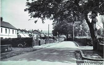
A tree lined view on entering Gilnahirk Road with Cherryvalley road to the right in 1950. The profile of Cherryvalley Shops has not changed much since they were constructed by Joe McMaster in the mid 1930s and the taller building at the end of the row is a grocery shop and petrol station.(Courtesy of H. Crawford Miller)

A reverse angle photo looking back towards King’s Road. The caption on this early 1950s tree-lined picture reads ‘The Village, Cherryvalley’. In the distance is the Co-op. In front of the shops is a parked Rover belonging to Chemist Joe Shillington which is outside the butcher’s, J. Williamson & Son. (Courtesy of Cecil Williamson)
 Cherryvalley ARP Post 457 was located at 3 Cherryvalley Gardens during the Second World War. In 1940 a group of ARP wardens are in Cherryvalley Park pulling a Slingsby handcart which has an extended cross T and is decorated with flags. They are collecting scrap metal for the war effort. (Courtesy of Maureen Dibble)

This is wedding party of First World War hero Lt. Colonel J.H. McCormick, DSO and Evelyn Campbell. They are standing in front of Evelyn’s parent’s house, Islandvale at 19 King’s Road in 1922. They were married in Knock Presbyterian Church and lived at 31 Gilnahirk Road in a house called ‘Vimy’ which was named after the First World War battle where J.H. McCormick won his medal. (Courtesy of Billy McCormick)

I lived in Cherryvalley Gardens from 1957 until 1975. A friend sent me this book recently and I enjoyed most of it, especially the old Cherryvalley Village photos and names from the past. I also believe in the charitable cause.
When we moved there I was 4 but vividly recall the bakery, Williamson’s, Ewings, Munn’s, Shillington’s (later Morley Thompson’s) Chemists, and Glaswegian Tommy Gibson’s Newsagent/Confectionery. Taylor’s garage had the wee lock ups in a big yard at the rear. My father parked his car there prior to getting a driveway and garage beside our house. Mr and MrsSH Bryce ran the Post Office at Kingsway Avenue. They sold me some great Dinky cars.
My father would regularly fill up at Greer’s garage on the King’s Road and my mother would shop at the new Co OP beside Greer’s garage. They had a new fangled bacon/ham slicer.
For my 11th birthday party, a group of us went round to the field beside the Co Op and kicked the ball around. Within a year or two the field was a shopping centre.
In the early 60’s there was a group of motor cycle roughs who hung around the wall between Taylor’s and Gibson’s shops, until one of them was killed on his motor cycle. I can’t remember his name, but he and his sister were twins.
I remember Crawford Miller well. His daughter Janet was a year younger than me. We all attended Gilnahirk Church.
I remember having to go to Jackson’s shop regularly to pick up potatoes, apples etc. Bobby Jackson and his wife both served in the shop. I knew their son Robert at Gilnahirk.
If I may – one or two comments. Mr Shillington’s car was a Ford Zephyr/Zodiac, not a Rover. There was too much about Knock, i.e. Sandown Road, Upper Newtownards Road and the ARP for my liking.
LikeLike
hello,i live in cherryvalley now and was wondering what is the arp?
LikeLike
Hi ARP is Air Raid Precautions.
“Air Raid Precautions (ARP) was an organisation in the United Kingdom set up as an aid in the prelude to the Second World War dedicated to the protection of civilians from the danger of air-raids.”
https://en.wikipedia.org/wiki/Air_Raid_Precautions
LikeLike
I lived at 10 Cherryvalley Gardens from May 1939 until after the 2nd world war. My parents photographs show them living there in 1930. Can anyone tell me when the houses were built.
LikeLike
I think it was built by the Belfast Corporation in the 1920’s. Identical to 39-43 Cherryvalley Gardens which were also built at that time. (I have a 1902 Ordnance Survey map of the area and Cherryvalley Gardens did not exist at that time)
LikeLike
Apologies, identical to 39-43 Cherryvalley Park (not Gardens)
LikeLike
I met a girl in Kincardine Ontario who said she was from
CheeryVelley…… very odd pronunciation.
LikeLike
I think that’s from 70s comic James Young’s Cherryvalley Woman
See: https://youtu.be/i0oMRPP03Y4?si=-Wlb7thsWTBCcvYZ
LikeLike
My parents knew James very well,
LikeLike
I’ve heard it being pronounced like that before too..
LikeLike
The comedian James Young used to pronounce it like that to poke fun at the alleged pomposity/snobbery/pretentiousness of its residents. I think he also told the joke “What is a creche ? A car accident in Cheeryvelley”
LikeLike
Hi,I lived at 5 Kings Brae from 52to76.I remember all the shops in the valley. Playing in the river, climbing trees in the old football field. I remember buying the girly mag “Parade” in Mazes shop. The old girl used to chase us out of the shop. I remember being ticked off by a policeman for riding my bike on the pavement. O thoughs where happy days. George Adair.
LikeLike
Hello all I believe my maternal great grandparents lived in Cherry Valley in the 30-40s. Their name was Brown. I think my great grandma was a school teacher. They had a daughter Isabella. I’d love to hear from anyone that may know of them
LikeLike